Sunday 22 July 2018

Run Hiking or Hike Running?

Today was day two of my short escape to mid Wales. Slept rather well again, but woke up with all my countless midges bites itching. And whatever bit a chunk of flesh out of my arm yesterday during lunch break, will be happy to know that as of this morning it's no longer stinging but itching and covering half of the inside of my upper arm with a red patch. Nice one.
Also found a tick on my calf just chilling and hanging in there. Didn't bring my tick tweezers so I left it for now. In fact, I was surprised to only have found one with all the high grass I had waded through the day before.
My chocolate tan had also not prevented me from getting a bit sun burnt under the overcast sky. Uh, the great outdoors, eh? I had certainly paid a price for all the fun.

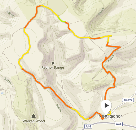
Sun was shining from a blue sky speckled with clouds. Tea, left over chilli for breakfast and off I went into Rhayader first to pick up some sun cream, then ever East all the way to a small village called New Radnor at the foot of Radnor Forest. Now, Radnor Forest may have been an actual forest once, but now it was just a series of hills with small spots of forest or rather plantation on it. Still, quite lovely to look at and three of those hills were amongst the numerous Welsh 2000s.
Today, I wanted to run to whole round. Is quicker and a different kind of workout. Got my new trail running backpack with pockets for water bottles in the front as well as storage for gels etc. Felt like a pro.

I set off around 10:15am along the main road through the village, then turned left uphill where the small tarmac road soon turned into a narrow - in places overgrown - path ever uphill. Looked like the perfect place to pick up a new friend for Mr. Tick. No one was interested though.


My initial light jog turned into a brisk walk, then a walk, then huffing and puffing as I made my way up as fast as I dared without exhausting myself too much already. It was very hot, so walking wasn't an issue at all. I had a lot of uphill still to go.

Passed through a plantation and then onto the open hill side. Lovely views over fields and hills not too far away. Very different compared to yesterday. The way up Bache Hill wasn't clear at all on the map. Fences around fields full of sheep were in the way. I found a broad path up along yet another fence very close to the summit, but it ended at the next field. Crossed it to pick up another path along a forest but between me and the summit was still an endless field of heather and not even the faintest path. Arg. In trainers and shorts I gave that one a miss. I'd come so close! But there were two more to go and I didn't fancy looking around for a way up. I'll come back for this one in hiking outfit. Then it would be no problem.

Over to Black Mixen. The hill top that is dominated by a huge mast of some sort and easy to see from far and wide. Slightly downhill (yay running!) to a col full of sheep shit and an armada of flies preventing any kind of relaxation for a short break, uphill straight after to the top of Black Mixen. The path was steep at first but then flattened out and the soft ground made for good progress of the running kind. Done enough walking so far.


Views were lovely still and I enjoyed them at the top for a well earned lunch break. A steady light breeze helped me cool down a bit, but the place wasn't inviting enough for a longer stay.

Really loved the next bit. A faint path led slightly downhill, the soft and almost bouncy ground made for great running, but winding it's way through a field of heather I bumpy enough to be great fun, I had to stay concentrated to not twist an ankle. After all there was not a soul in sight.

Reached another plantation and as I made my way over to the hulk of Great Rhos I actually met someone. A man walked the other way, said "Hi", then a pause, then "Wow...". And walked on. Felt well chuffed at that. In my cool trail running gear and all and running most of all. Didn't tell him I had walked most of the steep uphill. Hrhrhr.

Great Rhos top was marked by a trig point and after all easy to find. A see of heather surrounding it just like Bache Hill, but at least there was a nice bouncy path through it. Well, that was it, just had to get down now.
Followed the path as it was, but somehow got lost in the danger zone of the nearby shooting range. Ah! Danger! Somehow the path had turned into a sheeps track once more. So had to freelance down a steep slope upsetting a lot of sheep chilling there to climb over the fence at the bottom (long legs for the win). Phew.


Found  the path again and followed it all the way back down into New Radnor. Quite a lovely grassy and steep downhill bit that must be a killer going up. Splashed some spare water into my face, ah the relief!!! Back at the car after just under 10 miles (15k+) and over 1000m of ascent. Had taken me 2 hours 45mins excluding lunch break. Not bad at all.


Sat at the car for a bit sipping some recovery sports drink, splashing more water over my legs and arms.
After all a great day out. Some bits had been a bit meh, other bits great fun. It all had worked out pretty well. I had run the bits I could run and walked the bits that were just too steep. No shame in that. Still had taken time to take some photos or have a wee snack. It hadn't been a race or anything.
I think I'll do more of these. It's a bit hit and miss if you don't know the route or area and you may end up looking for the right path or have to walk a bit etc. But it's still worth it and you can explore so much more by just running instead of walking.

Back to Bristol in about 2 hours, unpacked, showered etc. Feel quite knackered now after two great days up in mid Wales. Go there if you're after outdoor adventures without the places being overrun by people.

Saturday 21 July 2018

Now, where exactly are you?

That's what Rich texted me last night when I was chilling at Elan Oaks campsite. I told him,  that I was just West of Rhayader and he still had no bloody clue.

To me and probably a lot of other hill walkers the space between the Brecon Beacons in South Wales and Snowdonia in North Wales is pretty much non existent. I've driven through this big area called Mid Wales a few times on my way to Snowdonia and every time I felt a bit lost. An endless undulating journey through  countless grey Welsh villages.

But there are places worth visiting if you dare to look for them. The prospect of two free days with Rich away on a boys weekend, made me look. Look at the map for some Welsh 2000s I have not yet climbed. And indeed I found five of them just East and West of said Rhayader.
Today I climbed the first two. Pitched in the rain at Elan Oaks campsite East of Rhayader Friday afternoon after a two and a half hour drive from Bristol.

Rhayader
A lazy overcast morning turned brighter as I took my time cooking breakfast. Headed into Rhayader first for a coffee and a wander around before heading back the same away and deeper into Elan Valley.
The place is a hidden gem. Ten minutes off the main A road you have hills rising left and right and rivers, reservoirs and dams in between.


It was overcast and muggy when I started my walk and heading slightly uphill in a broad path laid out with small slate chips, I already had sweat running down my back.
The path turned into a proper narrow grassy one half an hour later as I wound my way up a valley.


The scenery here is far from spectacular, but its barren absence of striking features bears a solemn dignity in its own.  This is a place for people who don't need to be entertained, who don't need the next thrill every five minutes. It's for those of us who like peace and quiet and nature in whatever shape it presents itself.


But places like this come with challenges still. The challenge of finding a/the path for instance. All too often you wander along a perfectly visible one, deep immersed in your own thoughts and all.of a sudden it's gone. You look back, yes there it is, you just came along it, you look forward and nothing. Just endless undulating hillside and grass.

Or you know you have to turn right, even your two GPS devices say so, but there surely is no path.  This is what happened to me an hour into the walk. Map said I'm in the right place, GPS said so,  reality didn't. Well, I went right (West actually) anyway labouring through endless knee deep grass with who knows what hidden by its green and yellow leaves. Oh and it was wet, too.
Keeping my eyes peeled all I could see were faint sheep's paths. Well better than wet grass, so I kept to those until I eventually saw what looked like a path well South of where it was on the map. Headed for it, stepped into a hidden hole, fell onto my knees, kept going. This stuff happens. Just doesnt look very elegant, haha.

On the path finally I was back on track for my first Welsh 2000 of the day: Drygarn Fawr. A steady breeze had set in, which was quite welcome and just after mid day I arrived at the top. Lengthy lunch break with views all the way to the Brecon Beacons. I could clearly make out Pen y Fan.

Drygarn with its two massive summit cairns in the distance
Distant Brecon Beacons
I could also see my next objective from here: Gorllwyn. Headed back down the nice path with boots and socks still wet from my grassy detour all the way to the main path and crossed straight over to head up to Gorllwyn. Map and GPS were absolutely certain that there was no path.  No. Yet there it was on the ground. Loosely following some wooden poles.

Great. Easy peasy,  I was loving this. And this was supposed to be the difficult part. Ha! Could already see the summit cairn to my right and bang... path gone. Like what the heck I was just on it a second ago. Screw it,  I freelanced to the top through crunchy bog. Gosh, don't wanna do this in the wet,  you'll sink in to your knees here.
Views at the top were... well, vast. There was just a lot of nothingness between anything of note in the distance. 


Time for the home stretch. Quick map check and I found a faint path heading into the right direction. Thank you, I'll take that.
I had already walked 17k, but still felt fresh. Saw a small llyn where the map showed a proper path again. Since I had just lost mine once more, I freelanced to it along some more sheep's paths, no problem.

And again nothing on the ground where the map said. Uh, well. Started walking into the general direction and eventually found something that could well be a path. Checked the map regularly just to make sure I was not following the wrong lead,  I eventually saw the valley and the river again from where I had started. Only had to circumvent a farm where the owner had decided that the path was not going through this time.


Made it back to the car around 4:30pm after having walked 22k today. Brilliant walk, but not for the beginner. I wouldn't want to do this in bad visibility or wet conditions. Had to keep my concentration up most of the time just to make sure I was headed the right way.
Back at the campsite at 5pm, I found it a lot busier. There's a party going on at one end,  luckily not at mine. I have a family with two young kids. Take that any time over party people.

Off to Radnor Forest tomorrow for another three Welsh 2000s... trail running this time!