Monday 28 April 2014

Infamous Dartmoor Here I Come!

After a crazy week including work on Saturday and with another crazy week at work ahead I can't express how much I'm looking forward to next weekend! It's a three-days-off bank holiday weekend and I had planned to do a mountain biking trip to Dartmoor in January already. Booked a rental car as it was unlikely for me to have my own yet at this point, bought a map and a mountain biking guide book.

Still I only came up with the actual routes yesterday and had a lot of fun figuring out where to go and what to do. The guidebook helped a lot as well as hitting the net though the routes that people publish online seldom have a grade so you kind of have to guess how difficult they are. 
I'm more a trail rider, I find no fun in steep descends and tricky bends. I want to enjoy the scenery while riding and don't want to go extra fast.

I'll drive down to Okehampton Friday night as soon as work allows and will camp at the Lydfort Campsite. Depending on the weather Saturday I could do two shorter trails nearby or when the view is good do the Military Road starting in Okehampton which is a nice 24km route mostly on a bridleway plunging deep into the moor.

There is plenty of choice for Sunday and Monday and I'll make that up as I go depending on the weather, mood and my physical condition, hehe. The Princetown-Burrator Loop is certainly on the top of my list.

Planned mountain bike routes
With car and tent I'm as mobile as possible and can literally do whatever I want. I can take the food I want without any limits to weight or packing size and I can sleep in the car or park it somewhere and pitch my tent. This is freedom! 

Monday 14 April 2014

Waymarked My A....

The drizzle had kept on pouring down all night and the firewood in the bothy was just too damp to have a nice fire going. We had dried a few small things like a shirt and gloves over the gas stove last night. We just wanted to get going to get warm so we packed our stuff and had our breakfast on the way. I put on full rain gear and even though it stayed dry for the moment I was happy for the extra warmth.
We walked along the river through some wood and stayed always close to the stream that became wider and wider. The path was very boggy in places and the going was a bit strenuous. Somehow we missed again the footpath leading to the West out of the woods and stayed on a tarmac road for quite a while until we hit the Beacons Way again which would lead us over two minor hills and to Table Mountain again. We would veer south earlier though, since we both didn't want to go near it again, haha.


Found the way marked trail around mid day and deemed ourselves almost back in Crickhowell. We lost it soon after as we took the wider path at a crossing and no sign pointed us into the right direction. I was doubting my navigation skills, but Ross was at a loss as well. Still with compass and map we found our way back and were soon led uphill. The weather worsened as we gained hight and soon we were up in the clouds again with a constant drizzle. What seemed like 2 miles on the map took us ages and when we finally reached the hill top we were drenched and miserable and just wanted to be back in Crickhowell.
Bring it on!!!
Followed the path down and eventually found us walking into the completely opposite direction. We were heading east instead of west. Arg! Neither of us had seen any sign of the Beacons Way so we had just followed the path. We had lost it again. This was getting very annoying. 
We decided to walk along some huge farms all the way to the west. There had to be a way down into the valley. We had a look at some gates here and there and indeed found a "Woodland Walk" sign on one. The gate was shut tight and didn't really look like the owner of the property wanted any walkers on his premises, but we didn't give a rat's arse and climbed over!
The path led straight down and we found ourselves finally down in the valley on a tarmac road again. I looked west and were delighted to see Table Mountain again! Yeah. Like a beacon it pointed us into the right direction. Another hour later we were back in Crickhowell.Totally knackered. Threw our stuff into the car's trunk, slipped into some dry clothes that we had hidden deep in our backpacks and went for food and a pint to a pub.

We really enjoyed our weekend again despite the shitty weather. The atmosphere in the clouds was really something quite different. I have to come back again when the weather is nice to really enjoy the ridge walk with those fantastic views. But I'd rather go somewhere else for a while to be honest, haha. 

Monday 7 April 2014

Waun Fach Ridge - Second Attempt

So there we were. Back in Crickhowell to give the Waun Fach ridge another go. Two weeks had past after our last hike including a very sunny weekend. Again we were rather unlucky. The forecast for Saturday looked a bit better with lots of clouds but little rain, Sunday had heavy rain all day. Hm. We didn't care much.
Ross had just acquired a car so going to Crickhowell was easy. We parked at a school and set off for Table Mountain again. This time he had packed less and another backpack, I had packed more with some more food and the stove, testing if my small 33L backpack is sufficient for my two-week June hike. It is. :)
We approached the hill from the east side and had no problems navigating although it was hidden in clouds half of the time. Low hanging clouds. Arg. Not very convenient for a ridge walk. Ross was in good shape today. I wasn't and I didn't really know why. It was like the other way around this time. He walked up easily while I was falling behind struggling. The different weight certainly played a role, also that I hadn't had my usual eggs and bacon for breakfast.
Walked up to Pen Cerrig-calch where we had to turn around last time. That was the easy part. The absence of any view whatsoever didn't really bother us. There was only little wind and there was a strange silence all around despite the chirp of a bird here and there. We loved it!

There is a Table Mountain hidden on this picture


On Pen Cerrig-calch
Stayed on the broad path going up and down, bagging the hilltops on the way. This ridge walk is said to be absolutely stunning with views as far as way into England. We had none of this, were lucky to get a tiny glimpse at the valley to the west at one point and even the hill tops ahead could only be seen briefly before they vanished again in the clouds within seconds.
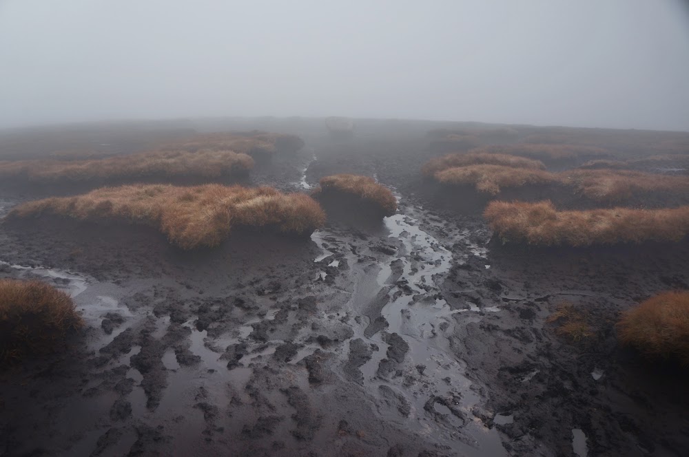
I was quite glad that I had just bought a new compass (the old one had the needle stuck all the time, don't buy a compass for a fiver). Soon hung it around my neck and used it quite frequently to check if we were heading into the right direction. We were and finally ascended the final long boggy approach of Waun Fach. In dense clouds with deeper getting lanes of black mud surrounded by dark red heather I suddenly realized that the birds had stopped singing. Ooohoooh. It almost felt like we were approaching the centre of an occult outdoor temple. Especially when the hilltop emerged: A large boulder in a round field of thick black mud. Woah! The boulder had a flat side almost like a slab at an angle. This looked so much like an altar! I looked for some old bloodstains, but found none, hahaha.

Something you won't expect to find on a hilltop

A brief moment of "view"

Waun Fach top with the slab barely seen in the distance


We walked down the other face of the hill and eventually the flora got greener and the birds were back again. Wow, what an experience! Found our way easy into the Gwryne Fawr valley with literally millions of frog eggs in the puddles on our path. Cool. Had never seen this. Met a few larger hiking groups which felt a bit weird since we had only met like a handful of other humans all day.
Reached the bothy near the damn at around 3pm. Since it was quite early we settled in, had some tea and food, took an afternoon walk to the dam and back. I introduced Ross to a game I loved in my youth "City, Country, River" (Stadt, Land, Fluss). Since there was only the floor to sleep on it was just enough for the two of us. Unfortunately another guy arrived late at night and we wouldn't shut him out since it had started to rain outside.
Somehow we squeezed all onto the floor. I could just stretch out, but Ross is a bit taller than me and had quite an uneasy night. Still it was better than staying outside in the tent and having to pack it wet and dripping next morning loading more weight.
Gwryne Fawr valley


Our shelter for the night


Friday 4 April 2014

And many happy returns...

Again quite spontaneously I'm off to the Black Mountains with my friend Ross this weekend. Since our original plan hadn't worked out last time we're going to give it another go. This time starting from Crickhowell passing by Table Mountain up to Pen Cerrig-calch where we had to turn around at our first attempt. Then all the way along the Waun Fach ridge, turning east at the end circling down into the Grwyne Fawr reservoir to the bothy there. Back to Crickhowell on Sunday via the valley.
Hopefully without any serious navigation errors this should be a rather relaxed walk, still demanding enough as we both realized that our fitness is not as good as it could be. Weather forecast is not too bad for Saturday at least. I will basically pack the same stuff I'll have normally with me for two weeks. Just a bit less food. So it's another good test, if I can somehow stuff all of it into my 33L backpack instead of the 40+5. Will also use my stove for the first time out in the field, yeah.

See you Sunday night!