Monday, 28 April 2014

Infamous Dartmoor Here I Come!

After a crazy week including work on Saturday and with another crazy week at work ahead I can't express how much I'm looking forward to next weekend! It's a three-days-off bank holiday weekend and I had planned to do a mountain biking trip to Dartmoor in January already. Booked a rental car as it was unlikely for me to have my own yet at this point, bought a map and a mountain biking guide book.

Still I only came up with the actual routes yesterday and had a lot of fun figuring out where to go and what to do. The guidebook helped a lot as well as hitting the net though the routes that people publish online seldom have a grade so you kind of have to guess how difficult they are. 
I'm more a trail rider, I find no fun in steep descends and tricky bends. I want to enjoy the scenery while riding and don't want to go extra fast.

I'll drive down to Okehampton Friday night as soon as work allows and will camp at the Lydfort Campsite. Depending on the weather Saturday I could do two shorter trails nearby or when the view is good do the Military Road starting in Okehampton which is a nice 24km route mostly on a bridleway plunging deep into the moor.

There is plenty of choice for Sunday and Monday and I'll make that up as I go depending on the weather, mood and my physical condition, hehe. The Princetown-Burrator Loop is certainly on the top of my list.

Planned mountain bike routes
With car and tent I'm as mobile as possible and can literally do whatever I want. I can take the food I want without any limits to weight or packing size and I can sleep in the car or park it somewhere and pitch my tent. This is freedom! 

Monday, 14 April 2014

Waymarked My A....

The drizzle had kept on pouring down all night and the firewood in the bothy was just too damp to have a nice fire going. We had dried a few small things like a shirt and gloves over the gas stove last night. We just wanted to get going to get warm so we packed our stuff and had our breakfast on the way. I put on full rain gear and even though it stayed dry for the moment I was happy for the extra warmth.
We walked along the river through some wood and stayed always close to the stream that became wider and wider. The path was very boggy in places and the going was a bit strenuous. Somehow we missed again the footpath leading to the West out of the woods and stayed on a tarmac road for quite a while until we hit the Beacons Way again which would lead us over two minor hills and to Table Mountain again. We would veer south earlier though, since we both didn't want to go near it again, haha.


Found the way marked trail around mid day and deemed ourselves almost back in Crickhowell. We lost it soon after as we took the wider path at a crossing and no sign pointed us into the right direction. I was doubting my navigation skills, but Ross was at a loss as well. Still with compass and map we found our way back and were soon led uphill. The weather worsened as we gained hight and soon we were up in the clouds again with a constant drizzle. What seemed like 2 miles on the map took us ages and when we finally reached the hill top we were drenched and miserable and just wanted to be back in Crickhowell.
Bring it on!!!
Followed the path down and eventually found us walking into the completely opposite direction. We were heading east instead of west. Arg! Neither of us had seen any sign of the Beacons Way so we had just followed the path. We had lost it again. This was getting very annoying. 
We decided to walk along some huge farms all the way to the west. There had to be a way down into the valley. We had a look at some gates here and there and indeed found a "Woodland Walk" sign on one. The gate was shut tight and didn't really look like the owner of the property wanted any walkers on his premises, but we didn't give a rat's arse and climbed over!
The path led straight down and we found ourselves finally down in the valley on a tarmac road again. I looked west and were delighted to see Table Mountain again! Yeah. Like a beacon it pointed us into the right direction. Another hour later we were back in Crickhowell.Totally knackered. Threw our stuff into the car's trunk, slipped into some dry clothes that we had hidden deep in our backpacks and went for food and a pint to a pub.

We really enjoyed our weekend again despite the shitty weather. The atmosphere in the clouds was really something quite different. I have to come back again when the weather is nice to really enjoy the ridge walk with those fantastic views. But I'd rather go somewhere else for a while to be honest, haha. 

Monday, 7 April 2014

Waun Fach Ridge - Second Attempt

So there we were. Back in Crickhowell to give the Waun Fach ridge another go. Two weeks had past after our last hike including a very sunny weekend. Again we were rather unlucky. The forecast for Saturday looked a bit better with lots of clouds but little rain, Sunday had heavy rain all day. Hm. We didn't care much.
Ross had just acquired a car so going to Crickhowell was easy. We parked at a school and set off for Table Mountain again. This time he had packed less and another backpack, I had packed more with some more food and the stove, testing if my small 33L backpack is sufficient for my two-week June hike. It is. :)
We approached the hill from the east side and had no problems navigating although it was hidden in clouds half of the time. Low hanging clouds. Arg. Not very convenient for a ridge walk. Ross was in good shape today. I wasn't and I didn't really know why. It was like the other way around this time. He walked up easily while I was falling behind struggling. The different weight certainly played a role, also that I hadn't had my usual eggs and bacon for breakfast.
Walked up to Pen Cerrig-calch where we had to turn around last time. That was the easy part. The absence of any view whatsoever didn't really bother us. There was only little wind and there was a strange silence all around despite the chirp of a bird here and there. We loved it!

There is a Table Mountain hidden on this picture


On Pen Cerrig-calch
Stayed on the broad path going up and down, bagging the hilltops on the way. This ridge walk is said to be absolutely stunning with views as far as way into England. We had none of this, were lucky to get a tiny glimpse at the valley to the west at one point and even the hill tops ahead could only be seen briefly before they vanished again in the clouds within seconds.
I was quite glad that I had just bought a new compass (the old one had the needle stuck all the time, don't buy a compass for a fiver). Soon hung it around my neck and used it quite frequently to check if we were heading into the right direction. We were and finally ascended the final long boggy approach of Waun Fach. In dense clouds with deeper getting lanes of black mud surrounded by dark red heather I suddenly realized that the birds had stopped singing. Ooohoooh. It almost felt like we were approaching the centre of an occult outdoor temple. Especially when the hilltop emerged: A large boulder in a round field of thick black mud. Woah! The boulder had a flat side almost like a slab at an angle. This looked so much like an altar! I looked for some old bloodstains, but found none, hahaha.

Something you won't expect to find on a hilltop

A brief moment of "view"

Waun Fach top with the slab barely seen in the distance


We walked down the other face of the hill and eventually the flora got greener and the birds were back again. Wow, what an experience! Found our way easy into the Gwryne Fawr valley with literally millions of frog eggs in the puddles on our path. Cool. Had never seen this. Met a few larger hiking groups which felt a bit weird since we had only met like a handful of other humans all day.
Reached the bothy near the damn at around 3pm. Since it was quite early we settled in, had some tea and food, took an afternoon walk to the dam and back. I introduced Ross to a game I loved in my youth "City, Country, River" (Stadt, Land, Fluss). Since there was only the floor to sleep on it was just enough for the two of us. Unfortunately another guy arrived late at night and we wouldn't shut him out since it had started to rain outside.
Somehow we squeezed all onto the floor. I could just stretch out, but Ross is a bit taller than me and had quite an uneasy night. Still it was better than staying outside in the tent and having to pack it wet and dripping next morning loading more weight.
Gwryne Fawr valley


Our shelter for the night


Friday, 4 April 2014

And many happy returns...

Again quite spontaneously I'm off to the Black Mountains with my friend Ross this weekend. Since our original plan hadn't worked out last time we're going to give it another go. This time starting from Crickhowell passing by Table Mountain up to Pen Cerrig-calch where we had to turn around at our first attempt. Then all the way along the Waun Fach ridge, turning east at the end circling down into the Grwyne Fawr reservoir to the bothy there. Back to Crickhowell on Sunday via the valley.
Hopefully without any serious navigation errors this should be a rather relaxed walk, still demanding enough as we both realized that our fitness is not as good as it could be. Weather forecast is not too bad for Saturday at least. I will basically pack the same stuff I'll have normally with me for two weeks. Just a bit less food. So it's another good test, if I can somehow stuff all of it into my 33L backpack instead of the 40+5. Will also use my stove for the first time out in the field, yeah.

See you Sunday night!

Wednesday, 26 March 2014

Way to Hill - Wales Weekender Pt.3


Despite being quite exhausted I slept rather uneasily. I wasn't used to a sleeping bag and the narrow mat anymore. It also took me a while to realize that there were no low flying military jets passing by every now and then but that the noise came simply from cars on the nearby A40.
There had been more showers during the night so I chose to pack my stuff at around 7:30 when it was dry for a moment. Peeled myself out of the tent to find a clear blue sky flecked with plump white and grey clouds.

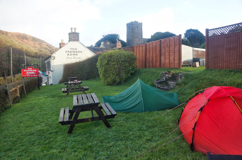
Been there done that: Camp in a pub garden
Had some salami, cheese and sardines for breakfast then stuffed everything into my backpack ready to go - you never know when the next shower comes - only to realize my waterproof jacket was still in the inner tent. ARG!
Ross was still sound asleep so I went around exploring. Found a church that looked like a castle, but the gate was closed. Walked a bit ahead on the Beacons way, had a staring duel with a sheep and found a cafe that was open! Yeah!
Back at the campsite I studied the map for today's route and found an easy one a bit on the Beacons Way and then heading over to Abergavenny on the Usk Valley Walk.
Ross emerged at 9 from his tent, we packed, had a nice coffee/tee and some Welsh cake at the cafe and headed off.
Ross' preferred hiking breakfast: half frozen Beanz
First along a minor road, determined only to take minor roads or official waymarked trails. Not 15 mins later we came across a public footpath that was a serious short cut according to our map and only about 2km long. We decided to give it a try. So much for resolutions, ha.
Walked over some fields with grand weather and the scenery behind getting more breathtaking with every climbed metre.


Of course we came to a junction after a while with no waymark. Arg! Public footpaths! The map said to go straight on, but the small gate had no sign and we could see no stile at the end of the field behind.
After checking the road to the left and right we decided to just take the gate which proved to be just right.
Arrived at a farm with a very nice farmer greeting us from his truck and walked down into Bwlch.
I had a sudden lust for milk and chocolate so we walked on to the bigger and easier to pronounce Llangynidr to have a break at the postoffice/convenience store.
Sitting under the canopy outside we dodged the only hail shower of the day munching chocolate and drinking milk.Then set off to walk along the Monmouthshire and Brecon canal all the way to Abergavenny. The path was lovely and easy, the underground almost too hard for such a long walk with heavy backpacks and hiking boots.


It took us much longer than I had estimated since we were just getting too tired. Arrived at the first houses of Abergavenny around 5pm. Relieved and happy at first we still had to walk looooong 3 miles to the railway station which took another hour and the help of some painkillers for Ross since his blisters were giving him the hardest time by now. (Quote Ross: "Is there anything you DON'T have in your backpack?" Hehehe.)

It took all our willpower not to fall asleep in the train, but we managed and got home around 8pm. What a great trip that was! The disappointment of not having bagged Waun Fach with its snowy top was outweighed by the lovely views and the pure joy of being outside. I had indeed missed this a lot! That not everything goes according to plan and that you have to make decisions and change plans... well that's part of the fun.
We will definitely go again, we're a good team out there. He will soon have a car, me too in about June. That will make spontaneous tours like this even easier.
The Black Mountains offer countless opportunities for walks as long as a day or a week even with still so many places to explore. They will be a good training ground for my other ventures later on. I'll be back!

Monday, 24 March 2014

Way to Hill - Wales Weekender Pt. 2

There really was no other way then to turn back and head down to Table Mountain again. Luckily the wind blew now from behind and right so our faces were not exposed to the hail shower. Whenever I turned around it felt like a thousand needles hitting my face. Within just a few minutes the underground was covered in tiny ice grains all around. It felt almost as if someone had literally put some icing onto the grassy slope. A grin crept onto my face as I realized that I seriously enjoyed this. Whatever nature comes up with, there is beauty in all of it.
Still smiling we descended further down, the wind and hail stopped eventually and back at fateful Table Mountain I asked Ross to decide. Go around the east face and head down to Crickhowell, pitch at the campitsite and have enough time to get a pint at a pub or go around the west face, head back to where we came from but keep going on the Beacons Way to Cwmdu and pitch at the campsite. He decided to go for the second and thus longer option.
We walked along the south face of some hills more or less level. with really nice views of the valley. Saw some sheep and some ponies which are really really tiny and not much bigger than big dogs. Most of them were quite shaggy and didn't care about us at all. Lovely.


Lost the path at some point as it just vanished and no waymarker pointed us in the right direction. I knew it just descended down for a bit before it would eventually come up again. So I led us along rather easy paths normally only trodden by sheep until we saw our foot path again and kept on going and going and going.
I must admit that the short bit we walked on the Beacons Way was really beautiful and the whole of it is definitely worth doing. Mental note.
Still, as the day was waning, its constant winding around farms and thus taking - in our exhausted state - unnecessary detours was a bit unnerving.
The thought of a pint in a pub kept us going at a more or less steady pace. I was already looking out for halfway decent places to pitch our tents as we had maybe half an hour of daylight left. A public footpath forked off to the left leading straight into the village presenting us with a nice short cut. We took it and ended up at a closed gate. Yay... Climbed back up to our path having lost precious 15 minutes and too much of the little strength we had left.
Passed by another public footpath and didn't even bother checking it. It was almost dark and the Beacons Way would lead us definitely into the village at some point. Then the path again led upwards instead of straight down into the village. No! From the looks of it, it just avoided another farm.
I left my backpack with Ross, ran back to the public footpath to have a quick look while there was still some light left. Not far down it met a tarmac road! Yes! That meant civilisation! Ran back to Ross and there we stood at that road not long after not knowing if we should head left or right. Took out our torches and decided to ask for the way at the farmhouse to the right.
I knocked and could see an old man hunched over a pot in his kitchen. He looked at me, I waved, he chose to ignore us and went out of the kitchen. Errr..... ooookay.
The other way then. After a few minutes we hit a dead end on a farm... again! We had more than enough. I was ready to pitch right here on the field. It was level, no livestock present and we would be gone in the morning. Then Ross remembered seeing a car on the farm, so the old man *had* to have access to a road. We went back and indeed, hidden behind a wall the tarmac road continued down! Yes! We had made it. We would not leave that road now, no matter how long we would have to walk. Ha!
Arrived in the village proper and met two ladies on our way to the campsite. Of course (!) it was still closed at that time of the year. I was determined to climb a fence if necessary, but they had a better idea and dragged us quite willingly to the pub. The nice owners offered us straight away to camp in the garden. Ha! Jackpot.
So we did. It was level and there was even light out there, perfect! We went inside after pitching our tents and had a few pints and a decent (for us the best) rump steak each. They had a fire burning and we could've just slept there right in front of the fireplace.
Eventually left the cosy warmth of "The Farmers Arms" pub and finally crawled stiff and aching into our sleeping bags.
What a day. We had walked a good distance - about 30km - and lost a lot of time re-routing for a number of reasons. We had enough of public footpaths and would definitely take an easier route tomorrow.

Way to Hill - Wales Weekender Pt. 1

Arrived after a reasonably short and uneventful journey on the train in Abergavenny at around 8:30am. Wow. It's only an hour away from Bristol and you're right in beautiful countryside at the foot of the Brecon Beacon National Park.

We waisted no time since we had a long day ahead of us. The plan was to bag Sugar Loaf Mountain first, then head over to Table Mountain and start the long walk on the ridge from there all the way to Waun Fach before circling back to Grwyne Fawr reservoir and spend the night in the bothy there.

That was the plan. Of course, we ended up somewhere completely different. The forecast promised a mix of sun and heavy rain and hail showers with even some thunder and lightning involved. The perfect weather for a ridge walk, haha. Headed off for Sugar Loaf anyway and decided to just go and decide what to do when it hits us.
One of too few sign posts
The sun warmed us, made us even sweat a good deal as we climbed higher. We could just don our rain gear before the first hail shower hit us. What a difference! It even turned into snow and was over after like five minutes, which proves my theory that hail never lasts long. Kept on going uphill with the view back down getting better and better.

Sugar Loaf Mountain (596m)


Didn't linger long on the exposed top and made our way down heading for Table Mountain next. So far map reading was easy. Now there were much more paths than on the map. We should've checked back with the compass. Ross had been on Table Mountain before and was sure he could spot it in the distance so we went for it.
After at least an hour of signs pointing to villages we couldn't find on the map and roads that didn't really match either, we finally arrived down at the A40 at a campsite that shouldn't be there. Time for the mobile phone and GPS. Turned out we had walked straight south instead of straight west. Arg! Luckily there was a bus stop with the next bus picking us up just 10 mins later. Phew. Jumped off at Crickhowell to start for Table Mountain. The whole episode had cost us at least 1.5 hrs maybe more and we learned our first lesson of the day: Double check, if one of us got a funny feeling about the direction, even if the other is 100% sure we're right.

We were in good spirits still and after a short break hit the well-known Beacons Way that passes by Table Mountain. This one should be waymarked and easy to find. Not 10 minutes later it lead straight through a farm - which is not unusual. Unfortunately there was a group of cows just right where we were supposed to pass. They didn't even bother looking at us. For a good reason. They had a massive bull in their midst, almost twice as big as the cows with horns as long as a man's arm. Huh! Oh, and the gate was open. Huh!!!
Ross was hesitant. There was easily enough space to walk around that group, he seemed to consider walking by.
I respect cows, they're big and curious and normally very harmless. A bull is a whole different matter. The way he looked at us so lazily almost like saying "Guys, this is my herd and my property and I got a horn for each of you." There was no way I was taking just one step closer!

So we took another detour quite voluntarily heading over fields, through a small wood - thus dodging the next hail shower - finally ascending Table Mountain whose top the Romans flattened to build a fort up there, giving it its distinctive shape. Sometimes it took us a while to find the next stile but in the end it was not hard to find our way, now that we knew where we were going.

Ross was tiring quickly, having underestimated the level of fitness needed. When we finally arrived at Table Mountain I left my backpack with him at the foot of the final steep ascend and literally ran up being freed of the heavy weight. Took a few pictures from the top before we headed up the slope to the first peak of the ridge we originally intended to walk.
Looking back to Table Mountain
The first part of the climb to Pen Cerrig-calch (701m) was rather steep, the second bit a loooong stretch going slightly up. The wind picked up a good deal and the clouds darkened around the cairn as I was approaching it. Not good. I knew then for sure that we were never going to make that ridge. When Ross arrived he was knackered. Even if the rest of the ridge was a lot easier to walk, it was just too late being almost half 3 now. We had about 3 hrs of daylight left.
Then hail set in. With those strong winds up there: not funny! What should we do? Keep on going in this mayhem? Bag another peak or two and then descend down into a valley? The map showed no real escape route.

Part two coming soon. :)